Hillfort - Zabytek.pl
Location and description
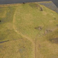
The hillfort is located approx. 1.5 km to the north-west of the centre of the Wicina village, among meadows and arable fields, on the south side of the channelled Szysznia river (sometimes referred to as a canal) and to the north of the channeled Widunia watercourse.
The hillfort in Wicina has a triangular shape with rounded corners, with dimensions of 163 x 168.5 m. At the south end, it is adjoined by an open settlement originating from the same period as the hillfort. The only road leading to the hillfort surrounded by small water courses and wetlands ran on the south side. The site was circumscribed by a defensive wall, currently levelled out and blurred to a great degree. A slightly sunk inner yard occupies a vast area.
History
At first, on a sand dune situated among swampy fields, in a valley of a small river (tributary of the Lubica river) an open settlement was founded. Over time, defensive reinforcements were built in the form of a wooden and earthen rampart. In the light of the recent surveys, among others, based on the results of dendrochronological analyses (the earliest date: 754 BCE), the construction of the hillfort began around the mid-8th century BCE and its destruction took place around the mid-6th century BCE. Prior to the burning down of the fortress a considerable section of the defensive rampart had been reconstructed and reinforced. The new rampart was approx. 6 m high and over 10 m wide at the base. The construction was never completed, since the hillfort was invaded by a group of armed persons associated with the Scythes, who completely destroyed it. The residents did not manage to save their belongings, therefore the layer of anthropogenic deposits yielded numerous items of a high value in terms of science and exhibitory potential, among others, bronze objects. The hillfort has never been rebuilt.
Progress and findings of archaeological fieldwork activities
The earliest mentions about single finds from the hillfort area date back to the second half of the 19th century, while the first excavation works were carried out in 1920 by a German scholar C. Shuchhardt. At that time several probing excavations were performed on the rampart and in the inner yard, aimed at analysing the structure of the buildings as well as chronology and cultural identity of the hillfort. Systematic excavation works were performed in the years 1966-1998 by Dr A. Kołodziejski. These works focused mainly on the northern and central part of the defensive complex. The most recent archaeological works took place in the years 2008-2009 and 2011-2012. The task of the team supervised by S. Kałagate was to complete the exploration of excavations opened during A. Kołodziejski’s surveys. A supplementation of the abovementioned excavation works was the performance of electromagnetic surveys covering the entire hillfort area and its surroundings by the Refugium company in 2009.
It was established as a result of the survey that, among others, the rampart circumscribing the hillfort, measuring 12-14 m in width, was made in a wooden and earthen structure of a lattice and, probably in part, box type. The rampart was most likely crowned with a palisade. Two phases of construction of this defensive structure can be distinguished. The later one - alteration - had taken place shortly before the burning down of the hillfort. A wooden road leading to the hillfort from the south and later bypassing the defensive complex towards the gate on the west and north side ran immediately in front of the rampart. The rampart was reinforced with a stockade on the external side. As claimed by A. Kołodziejski, initially the gate was located in the north-western part of the hillfort and only after the alteration of the defensive system was it relocated to the east part of the complex.
Residential buildings were located at the ramparts. The buildings were arranged with their longer axis parallel to an internal face of the rampart, probably in two rows. The dimensions of these structures, erected in a log- and pole-frame structure, measured 6 x 10-12 m. The central part of the inner yard, with a well in the middle, free of any buildings, was partly used for production purposes, as relics of a blacksmith, bronzemaking and two ceramic workshops were encountered during the excavations.
In the course of multi-annual archaeological surveys several million fragments of clay pottery and thousands of items and ornaments were found, mainly made of bronze, but also of iron, gold, amber, horn, bone, glass, stone and clay.
The hillfort is accessible all year round. Access is possible by a dirt road from the village.
Compiled by Dr Krzysztof Garbacz, National Institute of Cultural Heritage, Regional Branch in Zielona Góra, 14-12-2017
Bibliography
- Bugaj M., Nieinwazyjne badania osady obronnej w Wicinie, [in:] Blajer W. (ed.), Peregrinationes archaeologicae in Asia et Europa Joanni Chochorowski dedicatae, Kraków 2012, pp. 135-147.
- Bugaj M., Wicina. Pradziejowe grodzisko z wczesnej epoki żelaza, folder, 2017.
- Jaszewska A., Kałagate S. (ed.), Wicina. Badania archeologiczne w latach 2008-2012 oraz skarb przedmiotów pochodzących z Wiciny, “Biblioteka Archeologii Środkowego Nadodrza”, vol. 7, Zielona Góra 2013.
- Jaszewska A., Kałagate S., Grodzisko w Wicinie, woj. lubuskie, parkiem kulturowym, “Raport 11”, Warsaw 2016, pp. 227-238.
- Kałagate S., Orlicka-Jasnoch J., Gród obronny kultury łużyckiej w Wicinie, “Z otchłani Wieków”, R. 65, no. 1-4/2010, pp. 147-156.
- Kołodziejski A., Badania zespołu osadniczego ludności kultury łużyckiej z okresu późnohalsztackiego w Wicinie, pow. Lubsko, w latach 1966-1969, “Sprawozdania Archeologiczne”, vol. 23, pp. 93-108.

Category: hillfort
Protection: Register of monuments, Monuments records
Inspire id: PL.1.9.ZIPOZ.NID_A_08_AR.14394, PL.1.9.ZIPOZ.NID_E_08_AR.205916
Browse documents
5 documents
-
KEZA
2KEZA
-
inna
6inna
-
mapa obszaru AZP 1:25 000
1mapa obszaru AZP 1:25 000
-
sprawozdanie z badań
4sprawozdanie z badań
-
spis stanowisk alfabetyczny
6spis stanowisk alfabetyczny


Objects in this area
6 objects
-
Add to favorites Go to the subpage of the object ślad osadniczy, st. 32
Wicinaślad osadniczy, st. 32
6Show all