Hillfort - Zabytek.pl
Address
Tykocin
Location
voivodeship podlaskie,
county białostocki,
commune Tykocin - miasto
Location and description
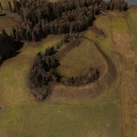
The Tykocin hillfort is located approximately 2.6 kilometres to the south of the town of Tykocin itself and just about 400 metres away from the road connecting Tykocin and Jeżewo. The town was erected on a small elevation believed to be of glacial origin. The hill was surrounded by a marshy valley towards the west and the north, with a small river flowing across the said valley. The area around the site is primarily agricultural land (mostly meadows). The site of the hillfort is partly overgrown with trees.
The well-preserved rampart was erected on an irregular oval plan. The total surface of both the rampart and the inner yard within is approximately 0.73 hectares. The hillfort was originally circumscribed by a moat, which has since been filled with earth.
History
The Tykocin hillfort was a centre of the Masovian people, located near the border with the Yotvingian territory. According to the preserved source documents, the hillfort remained under the control of the castellans of Wizna. An ancillary settlement located a few dozen metres to the west and to the south of the rampart is known to have functioned alongside the hillfort.
The archaeological surveys performed confirm that the hillfort in Tykocin was already in existence in the 12th and 13th centuries. The structure is believed to have only had a single phase of existence, since no trace has been found so far of any alteration works performed. The remains of the burned-out wooden structure which had once crowned the earthen ramparts mark the end of the fort’s existence. This, according to researchers, occurred somewhere during the 13th century.
Condition and results of archaeological research
A few series of excavation surveys were performed on the site of the stronghold in the years 1975-1982. Researchers who conducted these surveys were Zbigniew Jagodziński, Jerzy Gąssowski, Urszula Perlikowska-Puszkarska and Urszula Stankiewicz. In the years 1983-1990, the programme of studies was also extended to the neighbouring settlement. The results of the surveys made it possible to identify the fortification system and the manner in which the inner yard of the hillfort was originally used. Inside the rampart, a wooden latticework was discovered, consisting of multiple layers of wooden components positioned transversely towards one another and covered with sand. The entire structure was stabilised by means of vertical posts positioned along the edge thereof, on the moat side of the fort. A layer of stones was discovered alongside both edges of the rampart; among these stones were large boulders which increased the stability of the structure, although they might have also formed the traces of a stone lining of the inwards-facing side of the rampart. It has also been discovered that the upper sections of the wooden structure have been destroyed by fire. In addition, it has been determined that the defence system of the hillfort also included a moat approximately 2.5 metres deep and 9 metres wide. Inside the courtyard, a thick cultural layer was discovered, which proves that the fort had once seen intense use. Traces of a utility building have been discovered alongside the outer edge of the rampart, its dimensions being 3.8 x 1.8 metres. Over the course of a few seasons of research, the ancillary settlement located alongside the hillfort has also been analysed (Tykocin - site 2). Traces of buildings and accompanying utility structure have been found, as has a partially preserved cultural layer. Unfortunately, the survey has confirmed that the site has been severely damaged by agricultural use of the area. In the course of all the surveys performed, a large collection of moveable artefacts has been obtained, dating back to the 12th and the 13th century.
-
 Tykocin, hillfort, condition as of 27-04-2015, photo by Agnieszka Makowska.
 -
Tykocin, hillfort, condition as of 27-04-2015, photo by Agnieszka Makowska.
-
Tykocin, hillfort, condition as of 27-04-2015, photo by Agnieszka Makowska.
-
Tykocin, hillfort, condition as of 27-04-2015, photo by Agnieszka Makowska.
-
Tykocin, hillfort, condition as of 27-04-2015, photo by Agnieszka Makowska.
-
Tykocin, hillfort, condition as of 27-04-2015, photo by Agnieszka Makowska.
-
Tykocin, hillfort, condition as of 27-04-2015, photo by Agnieszka Makowska.
-
Tykocin, hillfort, condition as of 27-04-2015, photo by Agnieszka Makowska.
-
Tykocin, hillfort, condition as of 27-04-2015, photo by Agnieszka Makowska.
-
Tykocin, hillfort, condition as of 27-04-2015, photo by Agnieszka Makowska.
The hillfort is located in an area owned by the State Treasury.
compiled by Michał Sekuła, Regional Branch of the National Heritage Board of Poland in Białystok, 16-11-2015.
Bibliography
- Gąssowski J., Tykocin, woj. białostockie, Stanowisko 1, “Informator Archeologiczny”, Study year 1977, 1978, p. 205
- Jagodziński Z., Tykocin, woj. białostockie, “Informator Archeologiczny”, Study year 1975, 1976, p. 221.
- Perlikowska-Puszkarska U., Tykocin, woj. białostockie, Stanowisko 1, “Informator Archeologiczny”, Study year 1980, 981, p. 175.
- Perlikowska-Puszkarska U., Tykocin, woj. białostockie, Stanowisko 1, “Informator Archeologiczny”, Study year 1981, 1982, pp. 206-207.
- Stankiewicz U., Tykocin, woj. białostockie, “Informator Archeologiczny”, Study year 1982, 1983, pp. 230-231.
- Stankiewicz U., Tykocin, woj. białostockie, Stanowisko II, “Informator Archeologiczny”, Study year 1983, 1984, pp. 178-179.
- Stankiewicz U., Tykocin, woj. białostockie, Stanowisko II, “Informator Archeologiczny”, Study year 1984, 1985, p. 148.
- Stankiewicz U., Tykocin, woj. białostockie, st. 2, “Informator Archeologiczny”, Badania rok 1988, 1992, pp. 116-117.
- Stankiewicz U., Tykocin, woj. białostockie, St. II AZP 36-83/27, “Informator Archeologiczny”, Study year 1990, 1994, pp. 87-88.
Category: hillfort
Protection: Register of monuments, Monuments records
Inspire id: PL.1.9.ZIPOZ.NID_A_20_AR.20081, PL.1.9.ZIPOZ.NID_E_20_AR.495174
Browse documents
7 documents
-
KEZA
2KEZA
-
inna
1inna
-
sprawozdanie z badań
2sprawozdanie z badań
-
spis stanowisk alfabetyczny
2spis stanowisk alfabetyczny
-
spis stanowisk wg chronologii i funkcji
2spis stanowisk wg chronologii i funkcji
-
rysunek/fotografia zabytków ruchomych
12rysunek/fotografia zabytków ruchomych
-
mapa obszaru AZP 1:25 000
1mapa obszaru AZP 1:25 000


Objects in this area
8 objects
-
Add to favorites Go to the subpage of the object ślad osadniczy, st. 18
Tykocinślad osadniczy, st. 18
-
Add to favorites Go to the subpage of the object ślad osadniczy, st. 19
Tykocinślad osadniczy, st. 19
-
Add to favorites Go to the subpage of the object ślad osadniczy, st. 34
Tykocinślad osadniczy, st. 34
-
Add to favorites Go to the subpage of the object kwatera żołnierzy WP z I w. św.
War gravesBroniszewokwatera żołnierzy WP z I w. św.
8Show all