The Chodlik hillfort - Zabytek.pl
Address
Chodlik
Location
voivodeship lubelskie,
county opolski,
commune Karczmiska
Considered to be one of the so-called great Slavic hillforts, the structure was protected by no less than three ramparts with a total length of almost two kilometres. It is estimated that the settlement complex in Chodlik occupied an area of approx. 20 hectares - or between 80 and 100 hectares if we also include the nearby open settlements. The entire complex consisted of the strongly fortified hillfort as well as the extensive auxiliary settlement which adjoined it to the south-east. From 1997 onwards, a festival known as the May Day Archaeological Picnic has been held every year on the site of the hillfort.
Location and description
The hillfort is located in the western part of the village of Chodlik, about 200 metres in a straight line south-west of the last village buildings, 400 metres away from the Chodelka riverbed and about 2 kilometres north of the Żmijowisko hillfort. It is situated between the Chodelka and Jankówka riverbeds, in the south-eastern part of expansive floodplains which cover an area the shape of which approximates that of a triangle, its base paralleling the course of the Chodelka river. The hillfort lies in an area which used to be swampy and inaccessible, although it has since been drained. The site is known by its local name of “Szwedzkie Wały” (“Swedish Ramparts”).
The settlement complex in Chodlik consists of the remnants of a hillfort as well as of the auxiliary settlement which lies south-east of the fort. The hillfort is an example of a lowland fortified complex with a surface area of approximately 8 hectares, designed as a ring fort with three separate ramparts. The complex also featured a triple moat system designed to fend off potential attackers. Today, the remains of the fortifications can be discerned among the surrounding terrain mostly on the southern and western sections thereof, where the ramparts still reach the height of 2 - 2.5 metres in some places. An extensive auxiliary open settlement adjoins the hillfort to the south-east, its total surface being approximately 12 hectares. It is suspected that the remaining part of the hill (about 80 - 100 hectares in total) was used as arable land during the times when the hillfort remained inhabited. In the 1960s, a part of the former hillfort was intersected by an irrigation ditch and a road. Today, the site of the hillfort remains disused and is overgrown with grass as well as trees, since the nearby forest has since managed to encroach upon parts of the site.
-
 Chodlik, site no. 1, Karczmiska commune, hillfort, northern section, condition as of 2013, photo by Ewa Prusicka
 -
Chodlik, site no. 1, Karczmiska commune, hillfort, earthen ramparts in the eastern section, condition as of 2013, photo by Ewa Prusicka
-
Chodlik, site no. 1, Karczmiska commune, hillfort, earthen ramparts in the eastern section, condition as of 2013, photo by Ewa Prusicka
-
Chodlik, site no. 1, Karczmiska commune, hillfort, view of the inner yard and the southern section of the ramparts, condition as of 2013, photo by Ewa Prusicka
-
Chodlik, site no. 1, Karczmiska commune, hillfort, view of the inner yard and the southern section of the ramparts, condition as of 2013, photo by Ewa Prusicka
-
Chodlik, site no. 1, Karczmiska commune, hillfort, southern section, view of the earthen ramparts, condition as of 2013, photo by Ewa Prusicka
-
Chodlik, site no. 1, Karczmiska commune, hillfort, western section, view of the earthen ramparts, condition as of 2013, photo by Ewa Prusicka
-
Chodlik, site no. 1, Karczmiska commune, hillfort, western section, view of the earthen ramparts, condition as of 2013, photo by Ewa Prusicka
-
Chodlik, site no. 1, Karczmiska commune, hillfort, western section, view of the earthen ramparts, condition as of 2013, photo by Ewa Prusicka
-
Chodlik, site no. 1, Karczmiska commune, hillfort, western section, view of the earthen ramparts, condition as of 2013, photo by Ewa Prusicka
History
The hillfort in what is known today as the village of Chodlik has already been in existence during the early Middle Ages (between the 8th and the 9th century), with the accompanying open settlement remaining in use between the 9th and the 11th century. A. Gardawski, who explored the hillfort during the 1950s and the 1960s, has come to the conclusion that the ramparts around the fort have been erected in stages, starting with the inner rampart and followed by the middle and, finally, the outermost one. The author has also stated that the hillfort was being continuously extended throughout its lifetime. Today, however, the theory that the ramparts might have in fact all been erected at the same time is also considered acceptable.
There appear to be no mentions whatsoever of the hillfort in written sources. The Chodlik hillfort was discovered by A. Chotyński in 1907.
Condition and results of archaeological research
In the years 1952 as well as 1959-1962, an exploration of the site under the direction of A. Gardawski took place, followed by further research in years 1963-64 and 1966 (A. Gardawski, S. Hoczyk-Siwkowa) as well as in years 1968 and 1972 (A. Gardawski, I. Kutyłowska). In 1975, S. Hoczyk-Siwkowa carried out further research on the site. In the years 2000-2002, S. Hoczyk-Siwkowa and P. Lis conducted a series of excavations in the area. The research programme spanned a number of seasons and encompassed both the former inner yard of the hillfort, its ramparts and moats as well as the south-eastern auxiliary settlement.
Surface surveys of the site within the framework of the ‘Archaeological Picture of Poland’ project were carried out in 1980.
In 2002, M. Krąpiec carried out dendrochronological and dendrological analyses of the burned-out wood samples discovered in the course of archaeological research.
As a result, it has been determined that the defensive ramparts surrounding the now-vanished hillfort were by no means uniform in terms of their internal structure. Rampart no. 1 (the inner rampart, located closest to the inner yard of the hillfort and completely levelled in some sections) was the lowest of all three, with its height being a mere 0.70 metres, while its width was about 10 metres when measured at its base. It was purely an earthen bank, with no wooden inner structures whatsoever. It is suspected, however, that it might once have been topped with a palisade, allowing it to serve as the first line of defence. Rampart no. 2 (the middle one), with the height of about 1.30 metres and the width of approx. 12 metres at its base, was also a purely earthen structure in some sections, yet in other places it also featured a wooden internal framework (timber-laced rampart). Archaeological research was carried out on the southern, south-eastern and eastern sections of the rampart. Rampart no. 3 (the outer rampart) was likewise an earthen structure, although some fragments were designed as a box rampart instead. The sections which were examined by researchers were the southern, eastern and northern parts of the structure. A total of 120 metres of the northern section of the rampart are known to have originally been a box rampart, with a full outline of the base of a box-type structure made of heavy, scribe-fit interlocking wooden logs having been discovered inside one of the excavations; the outer and inner dimensions of this structure were 8 x 8.5 metres and 5.5 x 5.5 metres respectively, with the inside of the box being filled with earth. The discovery of the remains of charred timbers inside the ramparts clearly show that the hillfort has been destroyed by fire at some point. The residential buildings were mostly clustered in the southern section of the oval yard and in the area between the inner and the middle rampart, with the surviving remains of these structures being mostly the remnants of half-earth lodges made of wooden logs and equipped with stone hearths. No traces of any buildings were discovered in the northern part of the hillfort. In the middle of the inner yard there was a well with a timber casing made of scribe-fit interlocking logs; dendrochronological dating shows that the well was built back in the year 725 or 945. The exploration of the open settlement, on the other hand, yielded results in the form of remnants of man-made structures - hearths, storage pits and large clusters of moveable artefacts. In the course of the long exploration of the site, spanning a number of seasons, intriguing and valuable moveable artefacts have been unearthed, most of them being fragments of clay vessels of the so-called Chodlik type (made by hand and then turned, adorned with horizontal and undulating lines) as well as objects made of bone, metal and clay, flint and stone tools and animal bones. The most recent years have brought about a new discovery in the form of a barrow cemetery located in the vicinity of the remains of the hillfort. In the burial ground, traces of lavish burials of the ashes of men and horses have been found, with their mortal remains being deposited on the earthen structures of the mounds. Inside one of the mounds, charred bones of a man and a horse were discovered, along with bronze pieces of a harness and fragments of clay vessels dating back to the 9th/10th century.
The site is open to the general public.
compiled by Ewa Prusicka, Regional Branch of the National Heritage Board of Poland in Lublin, 14-10-2014.
Bibliography
- Gajewski L., Wyniki wstępnych badań na grodzisku wczesnośredniowiecznym we wsi Chodlik, pow. Puławy, “Wiadomości Archeologiczne’, vol. XX, 1954, pp. 86-89.
- Gardawski A., Z zagadnień kultury wczesnego średniowiecza południowej Polski, “Rocznik Lubelski” 1966, vol. 9, pp. 9-53
- Gardawski A., Chodlik. Część 1. Wczesnośredniowieczny zespół osadniczy w Chodliku. “Biblioteka Archeologiczna”, vol. 21, Wrocław-Warsaw 1970.
- Hoczyk-Siwkowa S., Chodlik, gm. Karczmiska, woj. lubelskie, “Informator Archeologiczny. Badania rok 1975”, Warsaw 1976, p. 166
- Hoczyk-Siwkowa S., Lis P., Najnowsze odkrycia na grodzisku w Chodliku, “Z Otchłani Wieków”, No. 1-4/2003, pp. 88-92.
- Kutyłowska I., Chodlik, pow. Opole Lubelskie, “Informator Archeologiczny. Badania 1968”, Warsaw 1969, pp. 222-223.
Category: hillfort
Protection: Register of monuments, Monuments records
Inspire id: PL.1.9.ZIPOZ.NID_A_06_AR.5984, PL.1.9.ZIPOZ.NID_E_06_AR.2136333,PL.1.9.ZIPOZ.NID_E_06_AR.2316618,PL.1.9.ZIPOZ.NID_E_06_AR.2105561
Browse documents
17 documents
-
KEZA
2KEZA
-
KEZA
2KEZA
-
KEZA
3KEZA
-
mapa obszaru AZP 1:25 000
1mapa obszaru AZP 1:25 000
-
mapa obszaru AZP 1:25 000
1mapa obszaru AZP 1:25 000
-
mapa obszaru AZP 1:25 000
1mapa obszaru AZP 1:25 000
-
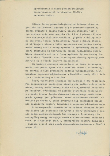
sprawozdanie z badań
1sprawozdanie z badań
-
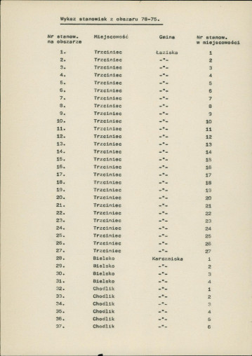
spis stanowisk wg numerów na obszarze
3spis stanowisk wg numerów na obszarze
-
spis stanowisk wg numerów na obszarze
1spis stanowisk wg numerów na obszarze
-
sprawozdanie z badań
12sprawozdanie z badań
-
sprawozdanie z badań
35sprawozdanie z badań
-
mapa inna
1mapa inna
-
spis stanowisk wg numerów na obszarze
4spis stanowisk wg numerów na obszarze
-
spis stanowisk alfabetyczny
4spis stanowisk alfabetyczny
-
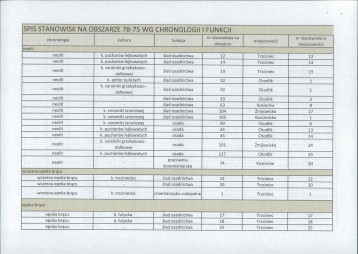
spis stanowisk wg chronologii i funkcji
6spis stanowisk wg chronologii i funkcji
-
spis stanowisk archiwalnych
2spis stanowisk archiwalnych
-
inna
66inna


Objects in this area
9 objects
-
Add to favorites Go to the subpage of the object ślad osadniczy, st. 24
Chodlikślad osadniczy, st. 24
-
Add to favorites Go to the subpage of the object ślad osadniczy, st. 21
Chodlikślad osadniczy, st. 21
-
Add to favorites Go to the subpage of the object ślad osadniczy, st. 15
Chodlikślad osadniczy, st. 15
-
Add to favorites Go to the subpage of the object ślad osadniczy, st. 32
Trzciniecślad osadniczy, st. 32
9Show all