Hillfort - Zabytek.pl
Address
Chlebnia
Location
woj. mazowieckie, pow. grodziski, gm. Grodzisk Mazowiecki - obszar wiejski
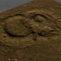
Its distinctive landform has the shape of rings of ramparts and is clearly visible. In addition, the continuation of the settlement structures in this area resulted in the nearby city of Grodzisk being named after the local name. The structure is part of a larger settlement complex, consisting of a hill fort and settlements dating back to the High Middle Ages (site 2 and 3 in Chlebnia).
Location and description
The hill fort in Chlebnia, known locally as “The Swedish Mountains”, is located on waterlogged meadows in the area of the flat valley of the Mrowna river. Researchers believe that the currently regulated watercourse originally flowed on the eastern side of the hill, i.e., separated the fortified settlement from the neighbouring early medieval settlements, located approx. 60 m to the east (site 3 in Chlebnia, entry no. C-72) and approx. 200 m to the north-east (site 2, entry no. C-71).
The hill fort consists of two sections, with dimensions of approx. 100 x 150 m. It is composed of an outer line of ramparts, which are 1.5 - 2.5 m high and 9 m wide at the base and figure-eight-shaped in plan, and the inner small fortified settlement enclosed by the eastern and larger ring of outer ramparts. The small fortified settlement is an over 3.5-metre high conical motte. The area of the hill fort is now a wasteland. The area which was formerly occupied by both of the aforementioned open settlements is used as arable land or wastelands.
History
The period of use of the fortified settlement can be divided into two phases. Originally it was a ring fort dating back to the 11th-12th century or 12th-12th/13th century, complemented with a motte in the 13th century. The first one was erected in the area of the former open Lusatian culture settlement dating back to the 5th period of the Bronze Age ( (900-650 BC) or the beginning of the Iron Age (650-550 BC). The settlement situated closer to the fortified settlement dates back to the 7th-8th and 9th-13th century, the one located further away to the 7th-8th century.
Condition and results of archaeological research
The hill fort was known as early as the 1920s; verifications were carried out in 1950. Excavations in the area of the hill fort were conducted by Zofia Wartołowska between 1967 and 1970. In 1985, the hill fort and the settlements adjacent to it were registered during the surface surveys carried out within the framework of the “Archaeological Picture of Poland” project.
The ancillary settlements immediately adjacent to the fortified centre (pol. podgrodzie) and the rampart were subject to research excavation. It was found that the outer ramparts were built of humus sand, without inner wooden structures. Charred beams were discovered on the outside of the rampart. The inner side of the rampart in the western part of the hill fort revealed the remains of buildings. The maidan of the inner small fortified settlement in the eastern part revealed a cultural layer, i.e., a layer of a man-made soil with a thickness of up to 20 cm. Researchers, however, have been unable to identify specifically the phase of use of the fortified settlement during which the layer was formed. The core of the rampart surrounding the inner small fortified settlement was built of humus sand and gravel; an investigation of the remains of the rampart also revealed the use of wooden beams and stone.
Researchers who have been investigating this structure believe that the use of the hill fort can be divided into two phases: a ring fort with buildings on its inner side, on which earth structures have been preserved, and the later conical motte, also with buildings on its inner side. The buildings of the hill fort were entirely destroyed by fire. The problem of establishing the stages and dates of particular alterations to the hill fort were discussed by researchers and requires scientific verification.
Settlement no. 2 in Chlebnia has not been subject to excavation so far, and the time at which it originated was established based on surface surveys. Settlement no. 3 in Chlebnia was partially investigated by Joanna Kalaga and Kazimierz Olsienkiewicz in 1995. Archeologists recorded historical structures and objects dating back to the beginning of the Bronze Age (probably associated with the Trzciniec culture), few moveable materials, which may date back to the 7th-8th century, and first and foremost cultural objects and build-ups from the 11th-13th century. The cultural layer on a layer of undisturbed soil, which means a geological stratum not affected by human activity, is 0.3 - 0.4 m thick and located directly on the surface.
It is vital to stress the importance of the movable monuments found during excavations of movable monuments dating back to the early medieval period. The sites which date back to that time were previously almost unknown in this region of Mazovia, which, it was thought, did not fall within the boundaries of the area where early Slavic tribes had settled.
-
 Chlebnia, hill fort, view from the north, condition as at October 2012, photo: Agata Byszewska.
 -
Chlebnia, hill fort, view of the conical motte from the west, condition as at October 2012, photo: Agata Byszewska.
-
Chlebnia, hill fort, view of the western ring of ramparts, condition as at October 2012, photo: Agata Byszewska.
-
Chlebnia, hill fort, view of the western part of the site from the rampart, condition as at October 2012, photo: Agata Byszewska.
-
Chlebnia, hill fort, view of the northern part of the western ring of ramparts, condition as at October 2012, photo: Agata Byszewska.
-
Chlebnia, hill fort, view of the southern part of the site from the west, condition as at October 2012, photo: Agata Byszewska.
-
Chlebnia, settlement no. 2 in Chlebnia, view from the south-west, condition as at October 2012, photo: Agata Byszewska.
-
Chlebnia, settlement no. 3 in Chlebnia, view from the north-west, condition as at October 2012, photo: Agata Byszewska.
The site is located in the immediate vicinity of Grodzisk Mazowiecki, on wastelands surrounded by arable land, outside built-up areas. The hill fort can be accessed from Chlewińska Street.
Compiled by Zbigniew Misiuk, Agnieszka Oniszczuk, National Heritage Board of Poland, 09.02.2014 r.
Bibliography
- Kalaga J., Naczynia ze starszych faz okresu wczesnośredniowiecznego na stanowisku nr III w Chlebni, gm. Grodzisk Mazowiecki, woj. stołeczne warszawskie, „Światowit”, Fascykuł B, vol. XLII, 1999, pp. 99-103.
- Kalaga J., Olsienkiewicz A., Chlebnia, st. III, gm. Grodzisk Mazowiecki, woj. st. warszawskie (AZP 59-62/6), „Informator Archeologiczny”, Badania rok 1995, 1998, p. 89.
- Kalaga J., Olsienkiewicz A., Osada przygrodowa na stanowisku nr III w Chlebni, gm. Grodzisk Mazowiecki, woj. stołeczne warszawskie. Przyczynek do studiów nad osadnictwem przygrodowym na Mazowszu południowo-zachodnim, „Światowit”, fasc. B, vol. XLI, 1998, pp. 483-496.
- Łoźny L., Grodziska Mazowiecki i jego okolice w okresie wczesnego średniowiecza, [in:] Dzieje Grodziska Mazowieckiego, J. Kazimierski (ed.), Warszawa 1989, s. 91-117.
- Miśkiewicz M., Osada wczesnośredniowieczna w miejscowości Grodzisk Mazowiecki, „Wiadomości Archeologiczne”, vol. 24, issue 4, 1957, pp. 388-389.
- Pyrgała J., Chlebnia, gm. Grodzisk Mazowiecki (d. pow. Grodzisk Mazowiecki), woj. stołeczne warszawskie, [in:] Grodziska Mazowsza i Podlasia (w granicach dawnego województwa warszawskiego), collective work, Wrocław -Warszawa -Kraków -Gdańsk 1976, pp. 29-30.
- Wartołowska Z., Z. Woźnicka, Chlewnia, pow. Grodzisk Mazowiecki, „Informator Archeologiczny”, Badania rok 1967, 1968, pp. 205-206.
- Wartołowska Z., Z. Woźnicka, Chlebnia, pow. Grodzisk Mazowiecki, „Informator Archeologiczny”, Badania rok 1968, 1969, pp. 221-222.
- Wartołowska Z., Z. Woźnicka, Chlebnia, pow. Grodzisk Mazowiecki, „Informator Archeologiczny”, Badania rok 1969, 1970, pp. 242-243.
- Wartołowska Z., Z. Woźnicka, Chlebnia, pow. Grodzisk Mazowiecki, „Informator Archeologiczny”, Badania rok 1970, 1971, p. 157.
Category: hillfort
Protection: Register of monuments, Monuments records
Inspire id: PL.1.9.ZIPOZ.NID_A_14_AR.43251, PL.1.9.ZIPOZ.NID_E_14_AR.2029477
Browse documents
7 documents
-
KEZA
2KEZA
-
mapa obszaru AZP 1:25 000
1mapa obszaru AZP 1:25 000
-
sprawozdanie z badań
1sprawozdanie z badań
-
inna
1inna
-
spis stanowisk wg numerów na obszarze
3spis stanowisk wg numerów na obszarze
-
spis stanowisk alfabetyczny
3spis stanowisk alfabetyczny
-
spis stanowisk wg chronologii i funkcji
2spis stanowisk wg chronologii i funkcji


