Hillfort - Zabytek.pl
Address
Warszawa
Location
woj. mazowieckie, pow. Warszawa, gm. Warszawa
Location and description
The settlement complex is located in the area of the Bródno Forest. The fortified settlement was originally on a dune sited over marshes stretching between the Skurcza and Ząza rivers. Due to its location it served a refugial function as a place providing safety and shelter to the people living in the nearby settlement.
The fortified settlement in Bródno is classified as a ring fort with an oval outline. Its dimensions are about 40 x 47 m. The rampart which was partially reconstructed and secured in the process of creating the Warsaw Archaeological Park (Warszawski Park Archeologiczny) is about 2.5 m high above the level of the maidan, which is the inner part of the ring fort. The present-day entrance to the maidan is located on the north-western side of the structure. The settlement is now a flar wooded glade adapted for recreational purposes.
Since 2008 the site has been occupied by the Warsaw Archaeological Park (Warszawski Park Archeologiczny). Alterations included reconstructing and strengthening the rampart, preparing an educational path and the so-called Archaeological Glade with benches, shelters and a playground.
History
The fortified settlement dates back to the 10th century. It was destroyed in a fire at the beginning of the next century and has not been reconstructed ever since. The surrounding settlement located to the north-west of the ring fort was operating until the end of the 11th century.
Condition and results of archaeological research
The first monuments were found in Bródno at the beginning of the 20th century. Roman Jakimowicz, the then discoverer, however, was not sure if he came across the remains of a fortified settlement. The 1920s saw the discovery of burnt pillars protruding from the surface of the southern part of the rampart. However, the excavations were not started, and over time the ring fort was forgotten. Once again it was found in 1948. Archeological surveys of the ring fort and the neighbouring settlement were undertaken one year later. As part of further missions under the supervision of Krystyna Musianowicz, Bogusław Gierlach and Olga Lipińska, working groups, with interruptions, until 1990. The period from 2000 to 2002 saw further archeological surveys, but this time from the point of view of pre-investment planning.
The surveys revealed that the fortified settlement was a single-component complex fortified by a wooden and earthen rampart. Its lower part was built in a sandwich construction, i.e., thick wooden beams were arranged in layers, alternately longitudinally and transversely to the line of the rampart, whereas its upper part has a box structure with boxes filled with stones and clay. The base of the rampart was originally approx. 8.5 m wide and 6 m high. The remains of a 2-metre-wide entrance gate were found in the southern part of the complex. During the archaeological excavations in the area occupied by the gate a wooden box was unearthed which contained seed residues. The fortified settlement was not surrounded by a moat. The central part of the fortified settlement remained vacant, which led Krystyna Musianowicz to believe that it served as a shelter for local people.
The western part of the site revealed the remains of a bridge linking the fortified settlement and the extensive settlement situated to the north and west of it. The most interesting structures discovered in the area occupied by the settlement included the remains of a cottage featuring arcades, in which a wagon wheel and a scoop. It is possible that these were the remains of a production workshop. A survey of the site revealed a small building with a large amount of bedding used as a cowshed or pigpen, and fortifications guarding the marshy borders of the settlement.
-
 Warsaw-Bródno, ring fort, view from the south-west, condition as at 20 August 2014, photo: Agnieszka Oniszczuk.
 -
Warsaw-Bródno, ring fort, view from the west, condition as at 20 August 2014, photo: Agnieszka Oniszczuk.
-
Warsaw-Bródno, ring fort, entrance to the maidan, condition as at 20 August 2014, photo: Agnieszka Oniszczuk.
-
Warsaw-Bródno, ring fort, view of the northern part of the maidan, condition as at 20 August 2014, photo: Agnieszka Oniszczuk.
-
Warsaw-Bródno, settlement, view of the recreational areas at the location of the former settlement, condition as at 20 August 2014, photo: Agnieszka Oniszczuk.
-
Warsaw-Bródno, settlement, view of the recreational areas at the location of the former settlement, condition as at 20 August 2014, photo: Agnieszka Oniszczuk.
In 2002, an archeological investigation conducted further to the east between Kondratowicza Street and Toruńska Street revealed the remains of another early medieval settlement, which dates back to the 11th - 12th century, i.e., after the establishment of the complex described above.
The early medieval settlement complex in Bródno is open to visitors.
Compiled by Agnieszka Oniszczuk, National Heritage Board of Poland, 20.08.2014 r.
Bibliography
- Jaremek A., Bródno Stare, st. 1 - wstępne wyniki badań osady, „Światowit“, vol. IV (XLV), fasc. B, 2002, pp. 57-68.
- Lipińska O., Gród i osada podgrodowa na Bródnie Starym w świetle badań prowadzonych w latach 1949-1966, „Z Otchłani Wieków“, R. LVI, issue 1-2, 2001, pp. 82-90.
- Lipińska O., Warszawa - Bródno Stare Grodzisko „Zagórki” St. 15 AZP 55-67/16, [in:] Informator Archeologiczny. Badania 1990 r, Warsaw 1994, pp. 88-89.
- Malinowska-Sypek A., Sypek R., Sukniewicz D., Brzeziński W. (wprowadzenie), Przewodnik archeologiczny po Polsce, Warsaw 2010, pp. 329-331.
- Miśkiewicz M., Bródno Stare i jego znaczenie w rozwoju Mazowsza wczesnośredniowiecznego, „Z Otchłani Wieków“, R. LVI, issue 1-2, 2001, pp. 80-81.
- Musianowicz K., Chata z podcieniem odkryta w osadzie podgrodowej w Bródnie Starym, pow. warszawski, [in:] Sprawozdania PMA, vol. III, Warsaw 1949, pp. 175-184.
- Musianowicz K., Skrzynia na zboże z grodziska „Zagórki” w Bródnie Starym, pow. warszawski, [in:] Sprawozdania PMA, vol. IV, issue 1-2, Warsaw 1951, pp. 97-106.
- Musianowicz K., Koło od wozu i łyżka - czerpak, znalezione w chacie na Bródnie Starym, pow. warszawski, [in:] Sprawozdania PMA, vol. IV, issue 1-2, Warsaw 1951, pp. 115-121.
- Musianowicz K., Wyniki prac wykopaliskowych na grodzisku w Bródnie Starym, pow. warszawski (rok 1949), [in:] Materiały wczesnośredniowieczne, vol. I (1949), Warsaw 1951, pp. 83-90.
- Musianowicz K., Polskie badania wczesnodziejowe w 1950 r. Bródno Stare, „Przegląd Zachodni“, R. VII, no. 1-2, 1951, pp. 256-258.
- Musianowicz K., Sprawozdanie z prac wykopaliskowych w Bródnie Starym, pow. warszawski w r. 1950, [in:] Materiały wczesnośredniowieczne, vol. II (1950), Warsaw 1952, pp. 61-70.
- Musianowicz K., Sprawozdanie z prac wykopaliskowych w Bródnie Starym k. Warszawy za rok 1952, [in:] Materiały wczesnośredniowieczne, vol. III (1951), Warsaw 1953, pp. 54-58.
- Musianowicz K., Gród i osada podgrodowa w Bródnie Starym k. Warszawy, [in:] Materiały wczesnośredniowieczne, vol. IV, Warsaw 1956, pp. 7-97.
- Musianowicz K., Osada podgrodowa w Warszawie-Bródnie Starym w świetle badań 1961 r., „Wiadomości Archeologiczne“, vol. XXIX, issue 3, 1963, pp. 235-249.
- Musianowicz K., Wyniki badań w 1962 r. na osadzie podgrodowej w Warszawie-Bródnie Starym, „Wiadomości Archeologiczne“, vol. XXX, issue 3-4, 1964, pp. 246-266.
- Musianowicz K., Osada podgrodowa w Warszawie-Bródnie Starym, „Wiadomości Archeologiczne“, vol. XXXI, issue 2-3, 1963, pp. 203-215.
- Musianowicz K., Wczesnośredniowieczny wiejski ośrodek z przedmieścia Warszawy - Bródna Starego, [in:] Szkice z najdawniejszej przeszłości Mazowsza, W. Hensel (ed.), Wrocław-Warszawa-Kraków 1968, pp. 162-170.
- Musianowicz K., Umocnienia brzegu osady w Warszawie-Bródnie Starym, „Wiadomości Archeologiczne“, vol. XXXIII, issue 3-4, 1968, pp. 332-337.
Category: hillfort
Protection: Register of monuments, Monuments records
Inspire id: PL.1.9.ZIPOZ.NID_A_14_AR.43460, PL.1.9.ZIPOZ.NID_E_14_AR.1859689
Browse documents
7 documents
-
KEZA
2KEZA
-
KEZA
2KEZA
-
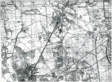
mapa obszaru AZP 1:25 000
1mapa obszaru AZP 1:25 000
-
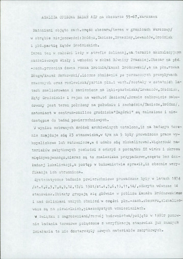
sprawozdanie z badań
2sprawozdanie z badań
-
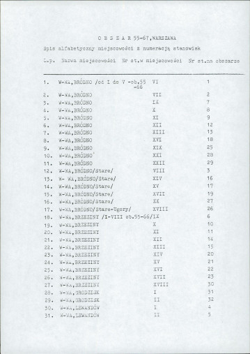
spis stanowisk wg chronologii i funkcji
1spis stanowisk wg chronologii i funkcji
-
spis stanowisk alfabetyczny
2spis stanowisk alfabetyczny
-
inna
1inna