Castle ruins - Zabytek.pl
Address
Stare Kolnie
Location
woj. opolskie, pow. opolski, gm. Popielów
The site has the shape of a hill overgrown with a clump of trees, among which are fragments of stone walls, talus, etc. A meadow separated from the river by the embankment extends around the ruins.
The castle was probably erected on the plan in the shape of an irregular quadrangle, on an earthen structure measuring about 80 cm in height. Remains of the walls mark the western, northern and eastern borders of the quadrangle. To the south, the wall was completely levelled, perhaps an entrance was there. The best-preserved part is the western section of the wall measuring about 16 m in length and about 3 m in width. It was built like the remaining sections of moraine cobblestone and large pebbles bound with lime mortar. The western sections joins the north one at an angle of about 100°. The walls is the longest part of the structure (its length together with a layer of rubble is about 25 m). It is connected to the most damaged eastern section at an angle of less than 90°. Researchers have not found any traces of the presence of a moat or a defensive rampart around the castle.
History
The earliest mentions of the castle are in written sources from 1316.
The Kolno (Coln, Callen, Kallen) castle was founded on the initiative of a duke most likely in the 13th century. The fortress adjoined a water customs office used to control the transport of wood and other goods on the right-bank tributaries of the Odra river on a large scale. In 1317, Bolesław III, Duke of Legnica and Brzeg, ceased to collect customs duties on merchandise in the Kolno castle and relocated the customs office to the Odra bridge in Brzeg. That decision was motivated by the desire to control the more frequent transport on the Odra river. Transport on the Stobrawa river has also decreased with the construction of an inland road near Siołkowice in 1316, allowing for the transport of trees from the forest by the Brynica river, directly to the Odra river. Thus, the fortress lost its meaning. The duke sold it as a hereditary property (allod) to one of his vassals. The new owners did not enjoy complete independence. In 1394, the owner of the castle, Witsche von Smogorow was ordered to keep his house in Kolno open to the duke at any time. Furthermore, the knight could not "host any harmful people at his court" (keine schedliche lewte off dem howfe zu halden).
In 1408, Witsche sold his "Haus und Sloz Coln" along with the adjacent villages to knights of the Blankenstein family. The duke insisted that his vassals did not sell the castle "to other owners as equal to them in terms of birth and nobility".
On 13 July and following days of 1443, during the civil wars in Silesia, the Castle of Kolno (Latin: Castrum Callen) was ruined and burned (Sommersberg 1729, p. 80: Castrum Callen ruptum fuit: Ipso die S. Margarethae & diebus sequentibus raptum & exustum fuit castrum Callen prope Bregam). In the same year, the Castle of Kolno together with the adjacent property was sold to the von Beess (Bies) lords, owners of the nearby castle in Karłowice. Representatives of that family collected duty on the timber transported on Stobrawa river. Only the burghers of Brzeg were exempted from the obligation to pay the duties. It is difficult to determine whether, despite the transfer of the customs office to Brzeg in the early 14th century, the duty was collected uninterruptedly at the Kolno castle, or only after the break from the moment of taking over the fortress by the Bies family. After 1546, when the castle was sold, there are no significant mentions of it in the records. In 1601, the duke gave his notary (Rentschreiber) "the place which was once occupied by the old castle (Orte wo etan das alte Schloss vorzeiten gestanden) ... without (?) two hills and other ruderibus so that he could build his house there". In the 18th century, the castle completely lost its significance.
-
 Stare Kolnie, castle ruins, view from the rampart towards the north-west, condition as of 2012, photo by E. Kalbarczyk-Klak
 -
Stare Kolnie, castle ruins, view towards the south, condition as of 2012, photo by K. Czartoryski
-
Stare Kolnie, castle ruins, view towards the south, condition as of 2012, photo by K. Czartoryski
-
Stare Kolnie, castle ruins, view towards the south, condition as of 2012, photo by K. Czartoryski
-
Stare Kolnie, castle ruins, central part of the site, condition as of 2012, photo by K. Czartoryski
-
Stare Kolnie, castle ruins, central part of the site, view towards the north, condition as of 2012, photo by K. Czartoryski
-
Stare Kolnie, castle ruins, central part of the site, view towards the east, condition as of 2012, photo by K. Czartoryski
-
Stare Kolnie, castle ruins, fragments of the walls 1, condition as of 2012, photo by K. Czartoryski
-
Stare Kolnie, castle ruins, fragments of the walls 2, condition as of 2012, photo by E. Kalbarczyk-Klak
-
Stare Kolnie, castle ruins, fragments of the walls 3, condition as of 2012, photo by K. Czartoryski
-
Stare Kolnie, castle ruins, fragment of the walls 4, condition as of 2012, photo by K. Czartoryski
The earliest mentions of the castle are in written sources from 1316. The ducal Kolno castle was built probably in the 13th century. In July 1443, during the civil wars in Silesia, it was ruined and burned, and in the 18th century it completely lost its importance. In the 1920s, demolition material was collected from the ruins to build a cloth factory in Brzeg, which was later also demolished.
Condition and results of archaeological research
The site was discovered during the penetration of the area of Silesia by Oskar Vuga in the 19th century, who the collected information published in his work Schlesische Heidenschanzen ihre Erbauer und die Hendelstrassen den Alten. Surface surveys on the site were conducted by Józef Kaźmierczyk and Z. Trudzik in 1957 and the exploratory surveys by Zbigniew Bagniewski in 1971. Excavations were conducted by the Museum of Opole Silesia in 1978, which resulted in the preliminary identification of the relics of the masonry buildings in the centre of the complex and revealed monuments dating from the late Middle Ages (metal and bone products, fragments of clay vessels) and monuments representing the Lusatian culture (fragments of vessels and spindle whorl).
In May 2010, Lech Marek, Ph.D., and his team conducted rescue excavations on the archaeological site. At that time, the researchers carried out surface surveys of the site using a metal detector, prepared documentation, made preliminary conservation of movable monuments, drew up a height map using an electronic tachymeter, and conducted a non-invasive inspection of magnetic field anomalies of the selected part of the site using a gradiometer. Excavations have revealed abundant historical material, including dozens of metal objects intended for military purposes. It was possible to determine the origin of the monuments, among others, based on the metal ceramics accompanying them, including the uncovered microliths of a brigandine, padlock, disc of a crossguard of a Bauernwehr, fragments of a stirrup and a spur, which were typical of the 14th/15th centuries. Their presence is likely to be related to the date of destruction of the castle in 1443, which is mentioned in the records.
Limited access. The monument is located on private land used as a meadow. It is clearly visible from the flood embankment.
compiled by Magdalena Przysiężna-Pizarska, Regional Branch of the National Heritage Board of Poland in Opole, 25-10-2014.
Bibliography
- Eistert K.., Historische Burgwallforschung im Kreise Brieg, Altachlesische Blätter, vol. 9, issue 1-3, 1934.
- Kubów P., Stare Kolnie gm. Popielów. Zamczysko. Opolski Informator Konserwatorski, pp. 83-85, 1981.
- Nowakowa J., Rozmieszczenie komór celnych i przebieg dróg handlowych na Śląsku do końca XIV wieku, Wrocław 1951.
- Marek L., Sprawozdanie z archeologicznych badań ratowniczych na stanowisku Stare kolnie, pow. opolski, gm. Popielów, Wrocław 2010, typescript.
Category: castle
Protection: Register of monuments, Monuments records
Inspire id: PL.1.9.ZIPOZ.NID_A_16_AR.5308, PL.1.9.ZIPOZ.NID_E_16_AR.1141189
Browse documents
6 documents
-
KEZA
2KEZA
-
inna
1inna
-
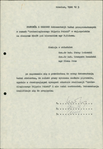
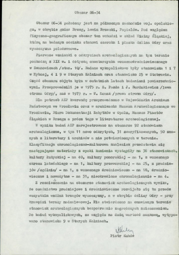
sprawozdanie z badań
1sprawozdanie z badań
-
spis stanowisk alfabetyczny
3spis stanowisk alfabetyczny
-
spis stanowisk wg chronologii i funkcji
8spis stanowisk wg chronologii i funkcji
-
mapa obszaru AZP 1:25 000
1mapa obszaru AZP 1:25 000